
El Niño is strengthening unusually quickly in the tropical Pacific, and official forecasts now indicate a high likelihood that it will become one of the strongest events measured since 1950. The phrase “super El Niño” is spreading through news reports and social media, but it is not an official scientific category. US forecasters call the highest category “very strong,” while the World Meteorological Organization describes the developing event as strong.
The distinction matters because a dramatic label can sound like a worldwide disaster forecast. El Niño instead changes the odds of heat, drought, rain and storms differently by region. Even a record ocean temperature does not guarantee that every familiar impact will occur.
What the latest forecasts actually say
The US National Oceanic and Atmospheric Administration said in its July update that El Niño will strengthen through the end of 2026 and has a 97% chance of lasting into early spring 2027. NOAA assigned an 81% chance that the event will reach its “very strong” category during October to December. Its latest weekly Niño-3.4 index was 1.2°C above the current reference average, while waters farther east were 2.7°C above average.
The World Meteorological Organization expects seasonal-average sea-surface temperature anomalies to exceed 2°C in key monitoring regions during July to September. It said major forecast systems agree closely on rapid strengthening, giving forecasters high confidence in the broad outlook. Warm water below the ocean surface, weakened trade winds and changes in tropical rainfall show that the ocean and atmosphere are now reinforcing each other.
“Super El Niño” commonly refers to an event whose central-Pacific warming reaches or exceeds 2°C, but agencies do not use one universal super-event definition. The temperature measure is also changing as NOAA adopts a relative ocean index designed to account for the warming tropical background. That makes precise comparisons with 1982–83, 1997–98 and 2015–16 more complicated than a single number suggests.
Asia and Australia face heightened dry-season risks
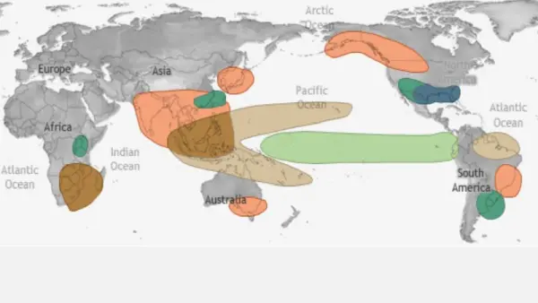
Across the Maritime Continent, El Niño often shifts tropical rainfall eastward into the Pacific. Indonesia’s BMKG expects more than half of the country’s seasonal zones to receive below-normal dry-season rainfall, with many areas facing a longer-than-usual dry season. That can pressure rice production, reservoirs and hydropower while increasing peatland and forest-fire danger.
The Philippines may also face dry spells and agricultural stress, although its southwest monsoon and tropical cyclones can still produce damaging local downpours. PAGASA advises farmers to conserve soil moisture, store rainwater and adjust planting schedules. This is a useful warning against reading a seasonal dry signal as a promise of dry weather every day.
Australia’s Bureau of Meteorology says parts of southern and eastern Australia are likely to be drier than average through September, while most areas are likely to be warmer. A possible positive Indian Ocean Dipole could reinforce the drying influence. The bureau cautions that event strength does not determine the size of Australia’s impacts, but risks include heatwaves, frost under clearer skies and more dangerous fire weather.
For India, the relationship is similarly probabilistic. El Niño often weakens the summer monsoon, but Indian Ocean temperatures, the monsoon circulation and shorter-term systems can offset or amplify it. Global models currently show a drier signal over parts of the subcontinent, making updated national and state forecasts more useful than the El Niño label alone.
The Americas could see rain, drought and fewer Atlantic storms
Peru and Ecuador face a particularly complex situation because warming immediately off their coasts can behave differently from warming in the central Pacific. Peru’s ENFEN committee expects the coastal event to continue while the global El Niño strengthens, and has urged authorities to prepare for the September 2026 to April 2027 rainy season. Warm water has already disrupted marine ecosystems and driven anchoveta into deeper or cooler areas, affecting fishing and seabirds.
Parts of coastal Peru and Ecuador can face intense rain and flooding, while Central America, the Caribbean and northwestern South America commonly lean drier during El Niño. That raises concerns for crops, drinking-water supplies and hydropower. Chile may receive episodes of heavy rain in some central areas, but local forecasts remain sensitive to storm tracks and the timing of Pacific warming.
In North America, a mature El Niño often favors wetter conditions across the southern United States during winter and warmer conditions farther north. It also strengthens upper-level winds that can disrupt Atlantic hurricanes. NOAA therefore gives the 2026 Atlantic season a 55% chance of below-normal activity, forecasting eight to 14 named storms. That does not remove landfall risk, because a quieter basin can still produce a destructive hurricane.
Africa may move from drought toward flood risk
The Greater Horn of Africa faces two contrasting phases. The regional climate center ICPAC forecasts below-normal rain and above-normal temperatures across Ethiopia, Sudan, South Sudan, Uganda and parts of Kenya from July to September. That could worsen water shortages, crop losses and food insecurity in areas already affected by conflict and displacement.
From October to December, ICPAC expects wetter conditions across Kenya, Uganda, Rwanda, Burundi, Somalia, Tanzania and parts of Ethiopia. Good rainfall could restore pasture and water supplies, but saturated ground, damaged infrastructure and settlements in flood-prone areas could turn that benefit into flash floods, landslides and disease outbreaks.
Southern Africa often becomes drier during El Niño in its main summer growing season, creating risks for maize and livestock. Forecast confidence at this lead time is lower, however, and rainfall will also depend on the Indian Ocean and regional circulation. Governments will need to watch spring updates before making major crop or water-allocation decisions.
Europe feels indirect effects and added global heat
El Niño’s influence on Europe is weaker and less consistent than around the tropical Pacific. Possible winter effects depend on how El Niño interacts with North Atlantic pressure patterns, so claims of a guaranteed wet, cold or stormy European winter are premature. The clearer global concern is temperature: El Niño releases ocean heat into the atmosphere on top of long-term human-caused warming, often lifting global averages during the event or the following year.
What to watch
The next major checkpoint is NOAA’s ENSO discussion scheduled for August 13, followed by updated WMO and national seasonal outlooks. Watch whether the Niño-3.4 index continues rising, whether Pacific winds and rainfall remain tightly coupled to the warming ocean, and whether a positive Indian Ocean Dipole develops.
Local preparation should follow local forecasts. Farmers, reservoir managers, health systems and emergency agencies need rainfall, river, fire and disease outlooks for their own areas, not just a global El Niño strength number. The strongest forecast is that risks are shifting. The exact weather will still be decided region by region.
Sources
- NOAA Climate Prediction Center, United States: July ENSO diagnostic discussion.
- World Meteorological Organization, global: July seasonal forecast.
- Bureau of Meteorology, Australia: national risks and forecast limitations.
- BMKG, Indonesia: 2026 dry-season outlook, Indonesian.
- ENFEN and SENAMHI, Peru: coastal and central-Pacific outlook, Spanish.
- ICPAC, East Africa: dry and wet phase regional outlook.
- NOAA Atlantic outlook, United States: 2026 hurricane-season probabilities.
This article was prepared with AI assistance and reviewed by a human editor. NewsBridges checked English-, Indonesian- and Spanish-language official forecasts and reporting.